Sunday, September 25, 2016

How High Will the Seas Rise, Really?

A recent high-profile study led by US climatologist James Hansen has warned that sea levels could rise by several meters by the end of this century. How realistic is this scenario?
We can certainly say that sea levels are rising at an accelerating rate, after several millennia of relative stability. The question is how far and how fast they will go, compared with Earth's previous history of major sea-level changes.
Seas have already risen by more than 20 cm since 1880, affecting coastal environments around the world. Since 1993, sea level has been rising faster still (see chapter 3 here), at about 3 mm per year (30 cm per century).
One key to understanding future sea levels is to look to the past. The prehistoric record clearly shows that sea level was higher in past warmer climates. The best evidence comes from the most recent interglacial period (129,000 to 116,000 years ago), when sea level was 5-10 m higher than today, and high-latitude temperatures were at least 2℃ warmer than at present.
The two largest contributions to the observed rise since 1900 are thermal expansion of the oceans, and the loss of ice from glaciers. Water stored on land (in lakes, reservoirs and aquifers) has also made a small contribution. Satellite observations and models suggest that the amount of sea-level rise due to the Greenland and Antarctic ice sheets has increased since the early 1990s.
Before then, their contributions are not well known but they are unlikely to have contributed more than 20 percent of the observed rise.
Together, these contributions provide a reasonable explanation of the observed 20th-century sea-level rise.
The Intergovernmental Panel on Climate Change (IPCC) projections (see chapter 13 here) forecast a sea-level rise of 52-98 cm by 2100 if greenhouse emissions continue to grow, or of 28-61 cm if emissions are strongly curbed.
The majority of this rise is likely to come from three sources: increased ocean expansion; glacier melt; and surface melting from the Greenland ice sheet. These factors will probably be offset to an extent by a small increase in snowfall over Antarctica.
With continued emissions growth, it is entirely possible that the overall rate of sea-level rise could reach 1 m per century by 2100 — a rate not seen since the last global ice-sheet melting event, roughly 10,000 years ago.
Beyond 2100, seas will continue to rise for many centuries, perhaps even millennia. With continued growth in emissions, the IPCC has projected a rise of as much as 7 m by 2500, but also warned that the available ice-sheet models may underestimate Antarctica's future contribution.

http://stem-works.com/external/article/1485


How High Will the Seas Rise, Really?
Acceleration and calving of the Columbia Glacier and other tidewater glaciers in the far north are a large reason glaciers and ice caps are contributing more to sea level rise this century than Greenland and Antarctica, says a new CU-Boulder study.
Credit: Robert. S. Anderson, University of Colorado


Midnight Sun to Keep IceHotel Open Year-Round

The IceHotel in JukkasjÀrvi, Sweden, is a destination for the hot-blooded — or anyone, for that matter, who thinks sleeping on a block of ice sounds cozy. Normally, the hotel is constructed in winter out of ice cut from a the Torne Riverand then left to melt as the temperatures outside turn to spring. But now, thanks to the midnight sun that shines all day long over the Arctic landscape, the IceHotel's sister, the IceHotel 365, will be open as many days as its name suggests.
The new hotel will built from river ice just like its sister, but will use solar-powered refrigeration to keep the frozen walls from melting."...we'll be able to produce roughly 75 kilowatts from April to September, which gives us an energy surplus that we can use to run our existing buildings, like our restaurants, offices and warm rooms," said founder Yngve Bergqvist in a press release.
Nine luxury suites, each with a sauna and bathroom, will accommodate guests brave enough to strip naked in freezing temperatures. An ice bar will serve chilled champagne and an ice gallery will present works of art.
Guests will be able to take year-round advantage of local activities, including dogsledding, watching the northern lights or taking a boat trip on the river — all beneath the light of the midnight sun.

http://stem-works.com/external/article/1563


Thursday, September 15, 2016

A massive heat wave is poised to envelop the U.S. from coast to coast next week

Following on the heels of the hottest June in the history of the lower 48 states, an extended, intense and widespread heat wave is likely to develop next week. 

The heat wave will start in the Plains states and parts of the intermountain West, eventually spreading to the West Coast, South and Midwest by Thursday, July 21. The heat wave is also likely to seep northward into southern Alberta and Ontario.
Cities like Dallas, Denver, Oklahoma City, Kansas City, Chicago, Minneapolis, Fargo and eventually New York City and Washington, D.C. may experience sizzling heat and stifling humidity by the end of the week.
During the height of the heat wave, a majority of the contiguous U.S. is likely to see high temperatures well above 90 degrees Fahrenheit, or 32 degrees Celsius. There will also be areas that will see temperatures climb into the 100s Fahrenheit, or above 38 degrees Celsius.

Another hazard may also be found along the northern fringe of the heat dome, from southern Canada across the northern Great Lakes states and into New England. Atmospheric disturbances tend to ripple across the outer edges of such weather patterns, triggering large complexes of severe thunderstorms.
While this is an extended range forecast with details that are subject to change, the warning signs for a major heat wave are present, and have been for several days, in several of the main computer models used to help predict the weather. 

Both the European, or ECMWF, and the GFS models are showing the extreme heat developing early in the week and growing more intense and widespread as the week goes on. 
One parameter meteorologists look at to judge the severity of a hot or cold streak is the height of a given pressure surface in the atmosphere. 
With hot air masses, a particular pressure surface will be found higher in the atmosphere, since hot air rises and causes a bulge to develop that pushes pressure surfaces above where they would normally be located. On the other hand, cold air masses feature below average heights.
http://mashable.com/2016/07/13/massive-july-heat-wave-coming-us/#K.yxCmOpcqqf


Tropical Depression Julia to meander off southeastern US coast for days..


Tropical Depression Julia will linger and bring periods of rain, gusty winds and rough seas to the coastal Carolinas through Friday.
"The center of Julia has wandered over the Atlantic Ocean," according to AccuWeather Hurricane Expert Dan Kottlowski.
Julia produced 3 to 6 inches of rain across portions of eastern Georgia and South Carolina as it tracked from northeastern Florida to off the Southeast coast on Wednesday.
With the storm expected to remain off the coast into Friday, the worst of the rain will stay offshore. Regardless, a few rain bands may move onshore bring a brief downpour and gusty winds to parts of the coastal Carolinas.
Additional rainfall totals along the coast will generally amount to an inch or less. Little or no rain will reach areas west of Interstate 95 through Friday directly related to Julia.
Julia maintained its intensity on Wednesday since becoming an official tropical storm on Tuesday night over northeastern Florida. Moderate wind shear is keeping Julia disorganized which caused the storm to weaken to a tropical depression early Thursday morning.

Wind shear is defined as the change in wind speed and direction with height. Tropical systems remain organized and strengthen in weak wind shear environments.
Should Julia hover over the warm waters of the Gulf Stream, some slow strengthening back to a tropical storm is possible. If Julia wanders inland again, the system would weaken and eventually become a tropical rainstorm.
Whether or not Julia weakens, strengthens or maintains its strength will depend on wind shear and the path the system takes over the next several days.
While Julia remains weak, the combination of east to southeast winds and the full moon will cause minor to moderate coastal flooding at times of high tide through the end of the week.
http://www.msn.com/en-us/news/other/tropical-depression-julia-to-meander-off-southeastern-us-coast-for-days/ar-BBw84d7?li=BBnbcA1&srcref=rss#image=1
Minor storm damage was reported


Tuesday, September 13, 2016

Crazy Winds


An NWS storm survey Thursday found storm damage consistent with an EF2 tornado, with estimated peak wind speeds up to 130 mph, along a 15.9-mile long path.
Calhoun County emergency management reported as many as four minor injuries with two trailers overturned north of Edison.
Five minutes later, a trailer was completely destroyed in Dickey, Georgia, with two injuries requiring immediate medical attention. Two other tornadoes were confirmed in Georgia, both rated EF0, in Webster and Stewart counties, according to NWS storm surveys.
NWS Tallahassee issued its first tornado warning for Calhoun County, including the towns of Edison and Dickey, 21 minutes before the tornado struck the trailer park just north of Edison and 26 minutes before it destroyed a trailer in Dickey.


https://weather.com/storms/tornado/news/southeast-severe-weather-georgia-florida

Rain storm in Arizona

The drenching monsoon rain that brought widespread flooding to the Phoenix area late Tuesday was a 1-in-100 year storm and just the latest historic storm to drench the nation.
A 1-in-1,000 year storm brought destructive flooding to the small Maryland town of Ellicott City last weekend. That event also marked at least the 9th 1-in-1,000 year rainstorm since 2010 and the third of 2016, following ones in Texas and West Virginia.
Overall, heavy rainstorms have been increasing over the entire U.S., most dramatically in the Northeast, the National Climate Assessment, a federal report said in 2014. ​A report by the National Academy of Sciences released earlier this year said a link between heavy rain events and global warming can be made with a "moderate" amount of confidence.
A 1-in-100 year rainstorm indicates that amount of rainfall in such a short time has a 1% chance of happening in any given year in a given location. A 1-in-1,000 year storm has a 0.1% chance of happening.
On Tuesday, more than 2 inches of rain pounded west and central Phoenix in about an hour, flooding major roads and highways. Several drivers needed to be rescued from flooded cars, but no injuries were reported.

http://www.usatoday.com/story/weather/2016/08/03/phoenix-arizona-monsoon-storm-floods/88002936/


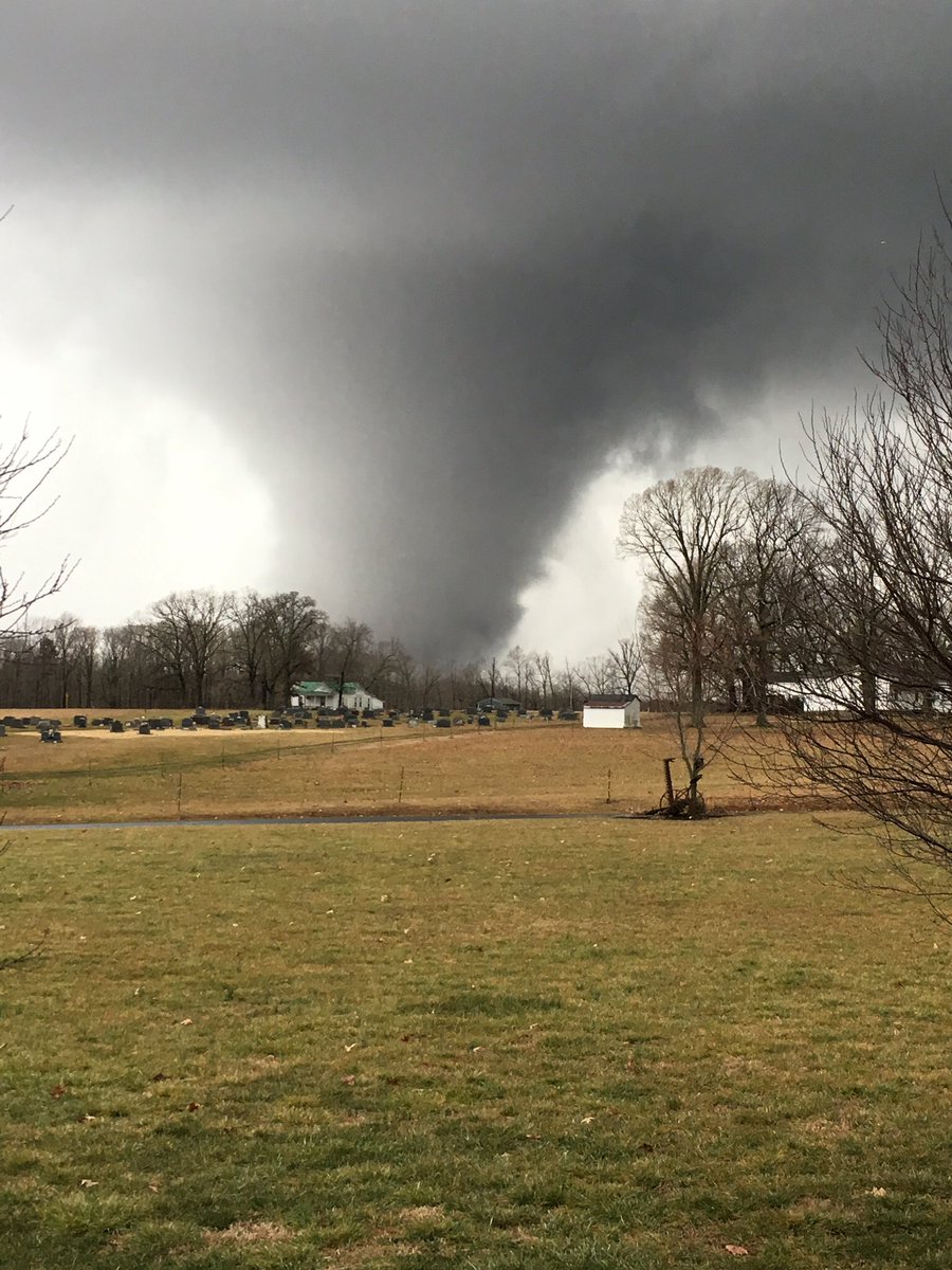
A tall and dusty twister in Virginia


A tornado touched down just inside the Campbell and Appomattox County line just south of county line road. This tornado continued to track northeast passing just to the southeast of the town of Appomattox impacting the community of Evergreen before ending around Holiday Lake State Park. This tornado was on the ground for 17 miles with a width of 400 yards…and damaged over 100 homes and structures…including one well-built brick house. One fatality and seven injuries resulted from this tornado.
This picture was taken by someone else, but I remember this tornado because my mother drove to Virginia for the week for her friend birthday and I remember her flying back home because this tornado tore her car into pieces !!!


Wednesday, September 7, 2016

Overnight Flooding Kills Five People in Texas Amid Violent Winds, Heavy Rains

A great-grandmother and her four great-grandchildren were killed amid heavy flooding in the east Texas town of Palestine, police said, as severe storms pummeled the region overnight Friday. 
"The water just came up extremely fast," Palestine Police Chief James Muniz told NBC News. "Before they knew it, water was waist-high, then chest-high, and then it was roof-line." 
The victims, who were discovered at about 3:45 a.m. local time, were identified Saturday afternoon as 64-year-old Lenda Asberry and her great-grandchildren Jamonicka Johnson, 6; Von Anthony Johnson Jr., 7; Devonte Asberry, 8, and Venetia Asberry, 9. She was their legal guardian, her son told NBC Dallas-Fort Worth


Palestine police said an additional six to eight families on their block had been displaced by the fast-moving floodwaters, and everyone else was accounted for.
Sometime after midnight, police received word that Lenda Asberry and her great-grandkids were missing, Muniz said.
"We started to get overwhelmed with calls," he said. "We had fire and other city workers out looking for them and once the water receded, we found them." 
The children lived with Asberry and were the only people in the home when the waters began to rise. 
Other residents on the block attempted to salvage belongings from their inundated homes. 
"All the residences are empty right now. The people are going to go back in a see if they can salvage anything," Muniz said.

http://www.nbcnews.com/news/weather/storm-weary-south-gears-more-rain-hail-tornadoes-n565091

Storm Newton

La Paz (Mexico) (AFP) - Tropical storm Newton roared into northwestern Mexico early Wednesday, making landfall a second time after leaving two people dead in Baja California, US forecasters said.
Downgraded from a hurricane, the storm was still packing 110 kilometer-an-hour (70 miles-per-hour) winds when it swept into mainland Mexico near Bahia Kino in the state of Sonora, the US National hurricane center said.
The storm was expected to dump eight to 15 centimeters (three to six inches) of rain, before passing into the US state of Arizona later in the day, the Florida-based weather center said.
After coming ashore for the first time early on Tuesday, the storm uprooted trees and shattered windows, leaving two dead in Baja California, as thousands of tourists hunkered down in hotels in the Los Cabos resort area.
But the region, which is very popular with American and Canadian tourists, managed to escape major damage, two years after Hurricane Odile ravaged Los Cabos, killing six people and causing $1 billion damage.
"According to the latest reports, #Newton only caused minor damages in infrastructure," President Enrique Pena Nieto wrote on Twitter, saying there were no injuries.
The storm caused a large swell that sunk a shrimp fishing boat between the Sea of Cortez and the Pacific ocean, leaving two people dead and three missing, said Los Cabos civil protection director Marco Antonio Vazquez.
The two bodies washed ashore on a beach. Vazquez said the boat had ignored warnings against going out to sea.
Vazquez said Newton's winds took down trees and tin roofs from poorer neighborhoods but that a disaster was averted because the hurricane passed through rural, sparsely inhabited areas.
Some hotel windows broke, but 14,000 tourists in Los Cabos were "safe" in rooms made to shelter them, said state tourism secretary Genaro Ruiz Hernandez.
Some 1,500 people took refuge in shelters in the resort town but many returned home, Vazquez said.
Power was cut to parts of Los Cabos and La Paz and the phone service was also disrupted.


https://www.yahoo.com/news/hurricane-newton-leaves-two-dead-mexico-030139162.html

Tuesday, September 6, 2016

During drought, dry air can stress plants more than dry soil


The finding suggests that models used to gauge the impact of drought on ecosystems should be refined to more accurately account for the role of low atmospheric humidity. It will become more important in the future, as the Earth's climate grows warmer and lower humidity has an increasing impact.
And as these humidity levels fall, plants may become less effective at removing carbon from the atmosphere, reducing their ability to offset climate change. At the same time, agricultural management strategies like irrigation, which improve soil moisture but have a smaller effect on humidity, may become less effective in the future.

https://www.sciencedaily.com/releases/2016/09/160905114521.htm

Wildfires, Once Confined to a Season, Burn Earlier and Longer

The first Alaska wildfire of 2016 broke out in late February, followed by a second there just eight days later.
New Mexico has had 140 fires this year, double the number in the same period last year, fueled by one of the warmest, driest winters on record.
And on the border of Arizona and California this month, helicopters dumped water on flames so intense that they jumped the Colorado River, forcing the evacuation of two recreational vehicle parks.
Fires, once largely confined to a single season, have become a continual threat in some places, burning earlier and later in the year, in the United States and abroad. They have ignited in the West during the winter and well into the fall, have arrived earlier than ever in Canada and have burned without interruption in Australia for almost 12 months.
A leading culprit is climate change. Drier winters mean less moisture on the land, and warmer springs are pulling the moisture into the air more quickly, turning shrub, brush and grass into kindling. Decades of aggressive policies that called for fires to be put out as quickly as they started have also aggravated the problem. Today’s forests are not just parched; they are overgrown.
In some areas, “we now have year-round fire seasons, and you can say it couldn’t get worse than that,” said Matt Jolly, a research ecologist for the United States Forest Service. “We expect from the changes that it can get worse.”
The 10.1 million acres that burned in the United States last year were the most since before 1960, and the top five years for acres burned since then were in the past decade. The federal costs of fighting fires rose to $2 billion last year, up from $240 million in 1985.
“We take our job to protect the public seriously, and recently, the job has become increasingly difficult due to the effects of climate change, chronic droughts and a constrained budget environment in Washington,” Tom Vilsack, the agriculture secretary, said in a statement, noting that seven firefighters died and 4,500 homes burned in wildfires in 2015.
Photo

http://www.nytimes.com/2016/04/13/science/wildfires-season-global-warming.html?_r=0

Monday, September 5, 2016

Coral Bleaching in the Great Barrier Reef

Study: Over 90% of Great Barrier Reef suffering from coral bleaching

(CNN)A study measuring the extent of coral bleaching in Australia's iconic Great Barrier Reef is branding some of the northern reef's problem as "extreme." 
As much as 93% of the 2,300 km (1,429 miles) reef suffers from some level of bleaching, according to the report from the ARC Centre of Excellence for Coral Reef Studies. Bleaching occurs when algae that live inside corals and give them their color are expelled -- either due to increased sea temperatures or extreme weather events. 
"The bleaching is extreme in the 1,000 km (600 mile) region north of Port Douglas all the way up to the northern Torres Strait between Australia and Papua New Guinea," says Andrew Baird of the ARC Centre.

"At some reefs, the final death toll is likely to exceed 90%. When bleaching is this severe, it affects almost all coral species, including old, slow-growing corals that once lost will take decades or longer to return."

But coral bleaching is also "the most widespread and conspicuous impact of climate change," according to the U.N.'s Intergovernmental Panel on Climate Change. Events like this one in the Great Barrier Reef are effects of climate change that scientists have predicted and feared.
Coral reefs are important to ocean ecosystems and continued bleaching events from ocean warming and acidification will damage reef-based fisheries and increase exposure to coastlines from waves and storms. It also will damage economies that depend on ecotourism, such as those in Australia and the Caribbean.
http://www.cnn.com/2016/04/20/asia/great-barrier-reef-coral-bleaching/index.html


Tropical Depression 9, an Impending Tropical Storm

According to an article on Nasa.gov a Tropical Depression, a precursor to a Tropical Storm, a storm less severe than a hurricane, by the name of Tropical Depression 9 is expected to “intensify over the next day or so.” The author, Hal Pierce claims that the reason the depression is expected to intensify is due to the vertical wind shear, the amount that the winds change with height, being low, and the fact that the depression is currently moving over warm waters.

            The GPM, Global Precipitation Measurement, an organization attempting to measure global rain fall amounts, found a series of storms within the Gulf of Mexico which were puring down upwards of 4.1 mm of rain per hour. According to Jeff Haby on theweatherprediction.com anything above .31 inches of rain per hour is considered to be a “heavy rain.” These series of storms happen to be falling at a rate several times higher than what could be considered a heavy rain fall. A few of these storms have begun to reach heights exceeding 9.9 miles. If the tropical storm continues to grow in this manner it will become a tropical storm by the name of Hermine.
-Drew Wilson
3D imaging of precipitation from tropical depression 9


Hurricane Hermine

Hermine expected to strengthen back into a hurricane as it creeps up East Coast...


Hermine moved far enough away from the East Coast on Sunday to remove the heavy rain but maintaining enough power to whip up dangerous waves and rip currents and keep beaches off-limits to disappointed swimmers and surfers during the Labor Day weekend.
As it churned hundreds of miles off shore in the Atlantic Ocean, the system picked up strength, and forecasters said it could regain hurricane force later as it travels up the coast. It was expected to stall over the water before weakening again to a tropical storm by Tuesday.
"It's just going to meander for a few days," Dennis Feltgen of the National Hurricane Center told the Associated Press, explaining that Hermine was unlikely to make landfall again but was positioned to batter the coast with wind and waves.
Governors all along the Eastern Seaboard announced emergency preparations. Tropical storm watches and warnings were in effect from Virginia to Massachusetts, with special concern focused on New Jersey and Delaware, where Rehoboth Beach could experience gusts up to 50 mph and life-threatening storm surges during high tide late Sunday and into Monday.

http://www.foxnews.com/us/2016/09/04/hermine-leaves-at-least-2-dead-as-it-makes-its-way-up-east-coast.html

Image result for hurricane hermine


California Drought & Wildfire

"Average global temperature in July 2016 was nearly 1.57 degrees above the 20th century average, beating the previous July record set in 2015. Dry and unstable weather conditions are contributing to a rapid increase in wildfire activity throughout California. As of August 29, there were 13 active wildfires, which had collectively burned over 260,000 acres.
The Chimney Fire in San Luis Obispo County grew by 10,000 acres in just over two days. To date, the fire has burned a total of 40,000 acres and is threatening to destroy the Hearst Castle, a state historical monument in San Simeon. The Soberanes Fire, which was started by an illegal campfire, has burned over 92,000 acres of wilderness and forest areas in Big Sur and nearby regions, making it the largest active wildfire in the state. Evacuation warnings are in effect, and nearby state parks remain closed.
Since the beginning of this year, wildfires have burned over 400,000 acres statewide. Click here to view CAL FIRE’s map of major wildfires in California."

"The State Water Resources Control Board has authorized a zero-percent water conservation target for 337 out of 379 water service providers (or 89%) that have submitted their “stress test” results to the Board, following the new guidelines in the Board’s Emergency Conservation Regulation. About 36 water suppliers indicated that they would face a supply shortage if the drought continues and are required to set their targets equivalent to the shortfall. Informational orders were given to eight water suppliers whose submissions were incomplete, unclear, or who appeared to have not followed instructions properly."


http://www.californiadrought.org/drought/current-conditions/

Image result for chimney fire san luis obispo